Get Certified for
Capital Markets (CMSA®)
From equities and fixed income to derivatives, the CMSA certification bridges the gap from where you are now to where you want to be — a world-class capital markets analyst.
A designation used by the Office of Management and Budget (OMB) to refer to a delineation consisting of multicounty clusters with a population density of at least 50,000
Metropolitan Statistical Area (MSA) is a designation used by the Office of Management and Budget (OMB) to refer to a delineation consisting of multi-county clusters with a population density of at least 50,000. An MSA broadly consists of a city with communities closely linked and exhibits a high degree of social and economic integration.

Metropolitan regions are neither administrative divisions like states or counties, nor are they legally incorporated as towns or cities. It means that the definition of any metropolitan region depends on the source.
A Metropolitan Statistical Area (MSA) represents a legacy of statistical definition that goes back to 1949. The definition of MSA advanced forth to tabulate the 1950 decennial data. The Bureau of the Budget, the predecessor to the current Office of Management and Budget (OMB), oversaw the vetting of MSA’s official definition.
MSA’s undergone minor renaming with associated rules modified and refined over the years. MSA changed to Standard Metropolitan Area (SMA) in1959 before acquiring its present name in 1983.
Even so, MSA’s retained its fundamental concept, with the delineation consisting of a two-step process. The first step is a designation of counties that consist of a settled core with a minimum population of 50,000. The second step is that it includes additional outlying counties or communities defined by a high level of economic and social integration.
The MSA concept serves to merge the developed lands of cities and counties with less densely settled areas surrounding them. The idea is to get specific geographical regions to compile statistical data, such as census data.
The criteria for delineating MSAs vary with a particular problem under investigation. For example, political problems often seek to address ethnic proportions, population equality, and district compactness. Most problems resulting from district partitioning dictates that new sub-regions be contiguous.
As a result, modern MSAs are partitioned to reflect spatially adjacent geographic areas with a densely settled core of the human population.
For a region to be spatially contiguous, movement from one point to another, within the region, must not extend outside. While it appears to be conceptually simple, it is nonetheless mathematically challenging, especially where modeling of spatial contiguity is involved.
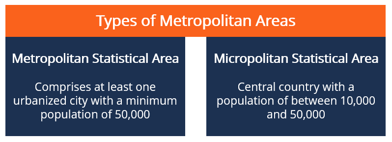
Like a Metropolitan Statistical Area (MSA), a Micropolitan Statistical Area is a designation used by the OMB for statistical reasons based on counties and their equivalents.
It centers on towns and the adjacent smaller communities whose populations range between 10,000 and 50,000. A Micropolitan Statistical Area must contain a city with a population fewer than 50,000 but not less than 10,000.
In contrast, a Metropolitan Statistical Area often incorporates a densely settled core city with a threshold of 50,000 or more people, including outlying counties. Close social and economic ties are usually at the core of a region defined by the MSA. Residents in the adjacent communities, for example, may walk within the city to shops, work, or attend social activities.
According to the OMB BULLETIN NO. 18-04, a total of 392 regions qualify to be delineated as Metropolitan Statistical Areas (MSAs) in Puerto Rico and the United States. Eight of the regions are in Puerto Rico, while the remaining 384 are in the United States.
Neighboring micropolitan and metropolitan statistical areas may be merged to become part of Combined Statistical Areas (CSA) if specific criteria are met in various combinations.
The concept of delineating the MSA is used by the Bureau of Labor Statistics (BLS) to analyze labor market conditions within spatial clusters. Workers within an MSA are likely to switch jobs without necessarily having to move to a new region – an underlying factor for a stable labor force.
Businesses and governments use the data to analyze information regarding spending patterns, unemployment rates, and per capita income. The resulting information is used for policy formulation to spur economic growth.
The data is also valuable to real estate investors, who use the information to study population movement and housing patterns.
CFI is the official provider of the global Capital Markets & Securities Analyst (CMSA®) certification program, designed to help anyone become a world-class financial analyst. To keep advancing your career, the additional CFI resources below will be useful: